Geolocate

Aritao topographic map

Click on the map to display elevation.

About this map

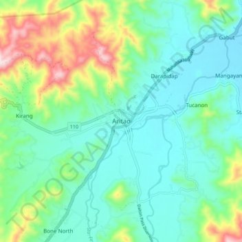
Name: Aritao topographic map, elevation, terrain.

Location: Aritao, Nueva Vizcaya, Cagayan Valley, 3704, Philippines (16.25689 120.99407 16.33689 121.07407)

Average elevation: 467 m

Minimum elevation: 346 m

Maximum elevation: 819 m

Other topographic maps

Click on a map to view its topography, its elevation and its terrain.

Kayapa

Philippines > Nueva Vizcaya

Average elevation: 1,258 m

Kasibu River

Philippines > Nueva Vizcaya > Kasibu

Average elevation: 866 m

Gear up for your next adventure:

🛶Kayak Dry Bag - Waterproof storage for kayaking adventures
🥾Hiking Shorts - Breathable shorts suitable for summer hikes
🧢Beanie Hat - Keep your head warm in cold weather
🔭Compact Monocular - One-handed bird watching and trail spotting
💡LED Headlamp - Hands-free illumination for night hiking and camping

As an Amazon Associate, this site earns from qualifying purchases at no extra cost to you.