
Make a donation
Gear up for your next adventure:
As an Amazon Associate, this site earns from qualifying purchases at no extra cost to you.
Dakar topographic map
Click on the map to display elevation.
Make a donation
Gear up for your next adventure:
As an Amazon Associate, this site earns from qualifying purchases at no extra cost to you.
About this map
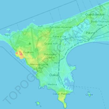
Name: Dakar topographic map, elevation, terrain.
Location: Dakar, Dakar Region, Senegal (14.64645 -17.54902 14.79664 -17.39660)
Average elevation: 7 m
Minimum elevation: -2 m
Maximum elevation: 92 m
Make a donation
Gear up for your next adventure:
As an Amazon Associate, this site earns from qualifying purchases at no extra cost to you.
Other topographic maps
Click on a map to view its topography, its elevation and its terrain.
Island of Gorée
Senegal > Dakar Region > Dakar
Recently, Hamady Bocoum et Bernard Toulier published an article "The Fabrication of Heritage: the case of Gorée (Senegal)" (in French: "La fabrication du Patrimoine: l’exemple de Gorée (Sénégal)") documenting the elevation of Gorée to an emotionally charged memorial of the transatlantic slave trade for…
Average elevation: 0 m