
Thank you for supporting this site ❤️
Make a donation
Make a donation
Gear up for your next adventure:
As an Amazon Associate, this site earns from qualifying purchases at no extra cost to you.
Potosí topographic map
Click on the map to display elevation.
Thank you for supporting this site ❤️
Make a donation
Make a donation
Gear up for your next adventure:
As an Amazon Associate, this site earns from qualifying purchases at no extra cost to you.
About this map
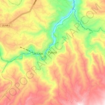
Name: Potosí topographic map, elevation, terrain.
Location: Potosí, Exprovincia de Obando, Nariño, RAP Pacífico, Colombia (0.76775 -77.61266 0.84775 -77.53266)
Average elevation: 2,843 m
Minimum elevation: 2,468 m
Maximum elevation: 3,160 m
Thank you for supporting this site ❤️
Make a donation
Make a donation
Gear up for your next adventure:
As an Amazon Associate, this site earns from qualifying purchases at no extra cost to you.