Geolocate

Kirang topographic map

Click on the map to display elevation.

About this map

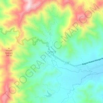
Name: Kirang topographic map, elevation, terrain.

Location: Kirang, Nueva Vizcaya, Cagayan Valley, 3704, Philippines (16.27869 120.98063 16.31869 121.02063)

Average elevation: 551 m

Minimum elevation: 385 m

Maximum elevation: 848 m

Other topographic maps

Click on a map to view its topography, its elevation and its terrain.

Kayapa

Philippines > Nueva Vizcaya

Average elevation: 1,258 m

Kasibu River

Philippines > Nueva Vizcaya > Kasibu

Average elevation: 866 m

Gear up for your next adventure:

🧦Thermal Socks - Warm socks for winter hiking or camping
🚲MTB Frame Bag - Carry tools and maps directly on your bicycle frame
🧦Crew Hiking Socks - Comfortable socks for long-distance hikes
🧭GPS Handheld Device - Reliable GPS navigation for outdoor adventures
🚲Handlebar Phone Mount - View topographic-map.com live while cycling

As an Amazon Associate, this site earns from qualifying purchases at no extra cost to you.