Geolocate

Inkerman topographic map

Click on the map to display elevation.

About this map

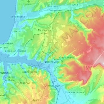
Name: Inkerman topographic map, elevation, terrain.

Location: Inkerman, Балаклавский район, Sevastopol, Ukraine (44.57913 33.56723 44.67871 33.73316)

Average elevation: 97 m

Minimum elevation: -3 m

Maximum elevation: 306 m

Other topographic maps

Click on a map to view its topography, its elevation and its terrain.

Херсонес

Ukraine > Sevastopol > Sevastopol

Average elevation: 2 m

Херсонес

Ukraine > Sevastopol > Sevastopol

Average elevation: 2 m

Sevastopol

Ukraine > Sevastopol > Sevastopol

Average elevation: 73 m

Gear up for your next adventure:

🧤Insulated Winter Gloves - Heavy-duty protection for sub-zero Canadian adventures
🛰️Satellite Messenger - Emergency communication for areas with no cell service
🧳Compression Sacks - Maximize space in your backpack by shrinking gear
🥾Light Hiking Boots - Lightweight and comfortable boots for day hikes
🦌Outdoor Trail Camera - Monitor wildlife activity near your favorite spots

As an Amazon Associate, this site earns from qualifying purchases at no extra cost to you.