
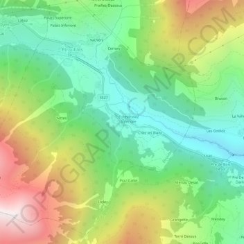
Échevennoz-Dessus topographic map
Interactive map
Click on the map to display elevation.
About this map
Name: Échevennoz-Dessus topographic map, elevation, terrain.
Average elevation: 1,633 m
Minimum elevation: 1,062 m
Maximum elevation: 2,582 m
Other topographic maps
Click on a map to view its topography, its elevation and its terrain.
Vachéry
Italie > Vallée d'Aoste > Creton > Vachéry
Vachéry, Creton, Etroubles, Vallée d'Aoste, 11014, Italie
Average elevation: 1,692 m
Prailles-Dessous
Italie > Vallée d'Aoste > Creton
Prailles-Dessous, Creton, Étroubles, Vallée d'Aoste, 11014, Italie
Average elevation: 1,783 m
Pallais-Dessous
Italie > Vallée d'Aoste > Creton
Pallais-Dessous, Creton, Étroubles, Vallée d'Aoste, 11014, Italie
Average elevation: 1,691 m
Rifugio Letey-Champillon
Italie > Vallée d'Aoste > Creton > Champillon
Rifugio Letey-Champillon, 1, Ru de Menouve, Champillon, Creton, Doues, Vallée d'Aoste, 11014, Italie
Average elevation: 2,432 m