Geolocate

Angamaly topographic map

Click on the map to display elevation.

About this map
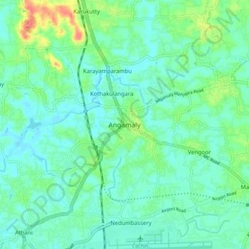
Name: Angamaly topographic map, elevation, terrain.

Location: Angamaly, Aluva, Ernakulam, Kerala, 683572, India (10.15103 76.34741 10.23103 76.42741)

Average elevation: 15 m

Minimum elevation: 0 m

Maximum elevation: 60 m

Other topographic maps

Click on a map to view its topography, its elevation and its terrain.
Mookkannoor

India > Kerala > Aluva > Ezhattumugham

Average elevation: 31 m

Thuravoor (Ernakulam)

India > Kerala > Aluva > Thuravoor

Average elevation: 22 m

Choornikkara

India > Kerala > Aluva > Aluva

Average elevation: 10 m

Choornikkara

India > Kerala > Aluva > Aluva

Average elevation: 10 m

Sreemoolanagaram

India > Kerala > Aluva > Thuruth

Average elevation: 11 m

Gear up for your next adventure:

🌡️Emergency Mylar Blankets - Compact thermal protection for unexpected nights outdoors
🍽️Titanium Camping Spork - Ultralight and indestructible eating utensil
🚑Survival Whistle - Signal for help across long distances in mountains
🛰️Satellite Messenger - Emergency communication for areas with no cell service
🦌Outdoor Trail Camera - Monitor wildlife activity near your favorite spots

As an Amazon Associate, this site earns from qualifying purchases at no extra cost to you.