Geolocate

Chinchaycocha topographic map

Click on the map to display elevation.

About this map

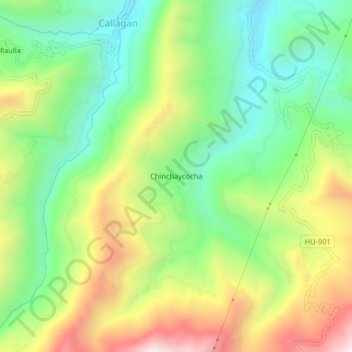
Name: Chinchaycocha topographic map, elevation, terrain.

Location: Chinchaycocha, Molino, Provincia de Pachitea, Huánuco, Perú (-10.00118 -76.06254 -9.96118 -76.02254)

Average elevation: 2,853 m

Minimum elevation: 2,496 m

Maximum elevation: 3,400 m

Gear up for your next adventure:

🧥Thermal Layer - Insulating layer for cold outdoor conditions
🔋Lithium AA Batteries - Long-lasting power that performs in extreme cold
🧢Sun Hat - Wide-brim hat for sun protection
🥾Light Hiking Boots - Lightweight and comfortable boots for day hikes
🧥Waterproof Hiking Jacket - Protect yourself from rain and wind while hiking

As an Amazon Associate, this site earns from qualifying purchases at no extra cost to you.