
Make a donation
Gear up for your next adventure:
As an Amazon Associate, this site earns from qualifying purchases at no extra cost to you.
Les Besses topographic map
Click on the map to display elevation.
Make a donation
Gear up for your next adventure:
As an Amazon Associate, this site earns from qualifying purchases at no extra cost to you.
About this map
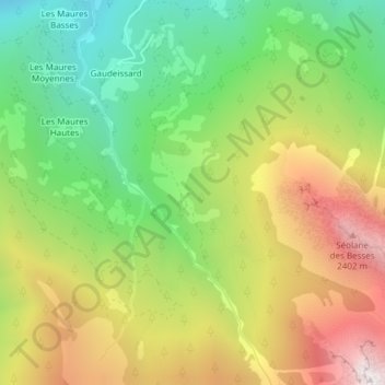
Name: Les Besses topographic map, elevation, terrain.
Average elevation: 1,668 m
Minimum elevation: 989 m
Maximum elevation: 2,538 m
Make a donation
Gear up for your next adventure:
As an Amazon Associate, this site earns from qualifying purchases at no extra cost to you.
Other topographic maps
Click on a map to view its topography, its elevation and its terrain.
La Blanche de Laverq
France > Provence-Alpes-Côte d'Azur > Alpes-de-Haute-Provence > Méolans-Revel
Average elevation: 1,913 m
Ailette
France > Provence-Alpes-Côte d'Azur > Alpes-de-Haute-Provence > Méolans-Revel
Average elevation: 2,122 m
04340
France > Provence-Alpes-Côte d'Azur > Alpes-de-Haute-Provence > Méolans-Revel > Les Bonnabaux
Average elevation: 1,708 m