Geolocate

Imalnod topographic map

Click on the map to display elevation.

About this map

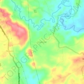
Name: Imalnod topographic map, elevation, terrain.

Location: Imalnod, Legazpi, Albay, Bicol Region, 4500, Philippines (13.04363 123.70429 13.08363 123.74429)

Average elevation: 45 m

Minimum elevation: 2 m

Maximum elevation: 104 m

Other topographic maps

Click on a map to view its topography, its elevation and its terrain.

Mayon Volcano

Philippines > Albay > Legazpi

Average elevation: 519 m

Sawangan Park

Philippines > Albay > Legazpi

Average elevation: 7 m

Kalayaan Park

Philippines > Albay > Legazpi

Average elevation: 7 m

Gear up for your next adventure:

🍽️Titanium Camping Spork - Ultralight and indestructible eating utensil
🧭GPS Outdoor Watch - Smart watch for navigation and fitness tracking in nature
🧤Rechargeable Heated Gloves - Extreme warmth for Canadian winter expeditions
🧣Merino Neck Gaiter - Protects against wind, sun, and cold at high altitudes
🥾Hiking Leggings - Comfortable leggings for outdoor activities

As an Amazon Associate, this site earns from qualifying purchases at no extra cost to you.