
Thank you for supporting this site ❤️
Make a donation
Make a donation
Gear up for your next adventure:
As an Amazon Associate, this site earns from qualifying purchases at no extra cost to you.
Arigoy topographic map
Click on the map to display elevation.
Thank you for supporting this site ❤️
Make a donation
Make a donation
Gear up for your next adventure:
As an Amazon Associate, this site earns from qualifying purchases at no extra cost to you.
About this map
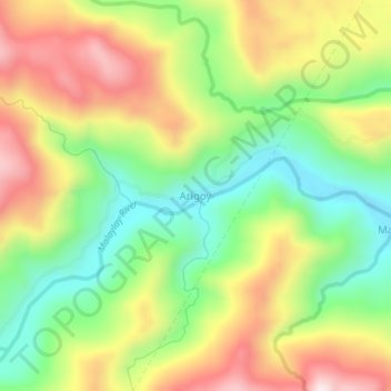
Name: Arigoy topographic map, elevation, terrain.
Location: Arigoy, San Teodoro, Oriental Mindoro, Mimaropa, Philippines (13.34975 120.94529 13.38975 120.98529)
Average elevation: 279 m
Minimum elevation: 38 m
Maximum elevation: 572 m
Thank you for supporting this site ❤️
Make a donation
Make a donation
Gear up for your next adventure:
As an Amazon Associate, this site earns from qualifying purchases at no extra cost to you.