Geolocate

Fabian topographic map

Click on the map to display elevation.

About this map

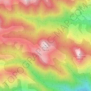
Name: Fabian topographic map, elevation, terrain.

Location: Fabian, Cricău, Alba, Romania (46.21278 23.47095 46.21288 23.47105)

Average elevation: 838 m

Minimum elevation: 550 m

Maximum elevation: 1,037 m

Gear up for your next adventure:

👟Leg Gaiters - Keep debris, mud, and snow out of your boots
🧦Outdoor Socks - Durable socks designed for hiking and outdoor sports
🧢Sun Protection Cap - Breathable cap to protect from sun exposure
🥾Trail Hiking Shoes - Durable shoes designed for rugged trails
🥾Light Trekking Boots - Supportive boots for multi-day treks

As an Amazon Associate, this site earns from qualifying purchases at no extra cost to you.