Geolocate

Jose Galvez topographic map

Click on the map to display elevation.

About this map

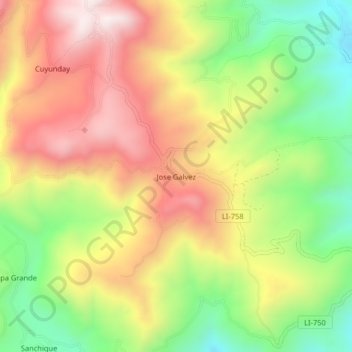
Name: Jose Galvez topographic map, elevation, terrain.

Location: Jose Galvez, Otuzco, Provincia de Otuzco, La Libertad, Perú (-7.92289 -78.61733 -7.88289 -78.57733)

Average elevation: 3,084 m

Minimum elevation: 2,729 m

Maximum elevation: 3,439 m

Gear up for your next adventure:

🌬️Windproof Camp Stove - Efficient cooking even on exposed mountain peaks
🌡️Emergency Mylar Blankets - Compact thermal protection for unexpected nights outdoors
🏃Hydration Running Vest - Carry water and maps close to your body for speed
🧥Packable Rain Jacket - Breathable waterproof layer for unpredictable weather
🧴Bear Spray Holster - Quick-access carry for essential Canadian wilderness safety

As an Amazon Associate, this site earns from qualifying purchases at no extra cost to you.