

Make a donation
Gear up for your next adventure:
As an Amazon Associate, this site earns from qualifying purchases at no extra cost to you.
Wigtown topographic map
Click on the map to display elevation.
Make a donation
Gear up for your next adventure:
As an Amazon Associate, this site earns from qualifying purchases at no extra cost to you.
Wigtown
Wigtown Castle was in existence by 1291, on flat land down by the River Bladnoch, (outlines clearly seen on an aerial view), whilst the town and church were on a hill, "an inversion of the usual arrangements". Nothing remains of the castle, although a strong natural site and indication of a large enclosed and defended area seems to point to a castle of the Edwardian type (Edward I) dating from the end of the 13th century. The site of the castle was excavated after a fashion about 1830, by a Captain Robert M’Kerlie and a team of volunteers. The outlines of a building were clearly traced on that occasion and a ditch, which had been broad, was distinctly seen on the north where there was also a semi-circular ridge of considerable elevation said to be the remains of the castle's outer wall. A few years later, a reporter in the New Statistical Account wrote that a fosse was quite discernible, although "the foundations of the walls cannot now be traced". Mortar and "other remains indicative of an ancient building" were still to be observed.
Make a donation
Gear up for your next adventure:
As an Amazon Associate, this site earns from qualifying purchases at no extra cost to you.
About this map
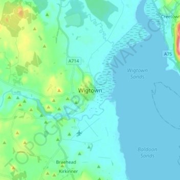
Name: Wigtown topographic map, elevation, terrain.
Average elevation: 18 m
Minimum elevation: -1 m
Maximum elevation: 131 m
Make a donation
Gear up for your next adventure:
As an Amazon Associate, this site earns from qualifying purchases at no extra cost to you.