
Vilamaior topographic map
Click on the map to display elevation.
About this map
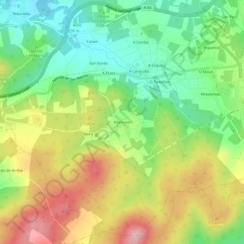
Name: Vilamaior topographic map, elevation, terrain.
Average elevation: 360 m
Minimum elevation: 262 m
Maximum elevation: 490 m
Other topographic maps
Click on a map to view its topography, its elevation and its terrain.
Santiago de Compostela
España > Galicia > Santiago > Santiago de Compostela
El relieve del municipio se caracteriza por una sucesión de montes entre los valles de los ríos Sar y Sarela. Además, el río Tambre hace de límite septentrional del territorio. La altitud oscila entre los 530 m (monte Espiñeira) y los 70 m a orillas del Sar. La ciudad se alza a 258 m sobre el nivel del mar.
Average elevation: 260 m
O Campón do Milladoiro
España > Galicia > Santiago > Santiago de Compostela > As Moas de Arriba
Average elevation: 241 m
Santiago de Compostela
España > Galicia > Santiago > Santiago de Compostela
La ciudad está situada entre dos montes prominentes, el monte Pedroso y el monte Viso. El relieve es variado, con zonas de colinas y valles que aportan un paisaje muy característico. La altitud varía desde los 70 metros sobre el nivel del mar en las orillas del río Sar hasta los 530 metros en el monte…
Average elevation: 276 m