Geolocate

Tanjungsari topographic map

Click on the map to display elevation.

About this map

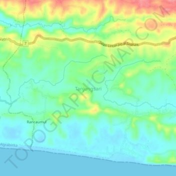
Name: Tanjungsari topographic map, elevation, terrain.

Location: Tanjungsari, Agrabinta, Cianjur, West Java, Java, Indonesia (-7.44539 106.92630 -7.40539 106.96630)

Average elevation: 25 m

Minimum elevation: -7 m

Maximum elevation: 80 m

Other topographic maps

Click on a map to view its topography, its elevation and its terrain.

Cidaun

Indonesia > West Java > Cianjur

Average elevation: 658 m

Kertajadi

Indonesia > West Java > Cianjur

Average elevation: 108 m

Agrabinta

Indonesia > West Java > Cianjur

Average elevation: 108 m

Karangwangi

Indonesia > West Java > Cianjur

Average elevation: 119 m

Wanasari

Indonesia > West Java > Cianjur

Average elevation: 31 m

Cisalak

Indonesia > West Java > Cianjur

Average elevation: 49 m

Jayapura

Indonesia > West Java > Cianjur

Average elevation: 73 m

Gear up for your next adventure:

Bushcraft Tarp - Versatile emergency shelter or gear protection
🔦LED Flashlight - Powerful and long-lasting flashlight for camping and emergencies
🥾Lightweight Hiking Boots - Boots for comfort and mobility on long hikes
🧢Sun Protection Cap - Breathable cap to protect from sun exposure
💡LED Camping Lantern - Illuminate your campsite with long-lasting lanterns

As an Amazon Associate, this site earns from qualifying purchases at no extra cost to you.