Geolocate

Shelburne topographic map

Click on the map to display elevation.

About this map

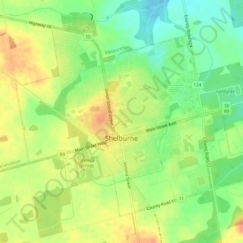
Name: Shelburne topographic map, elevation, terrain.

Location: Shelburne, Dufferin County, Central Ontario, Ontario, Canada (44.06788 -80.22346 44.09347 -80.17776)

Average elevation: 490 m

Minimum elevation: 468 m

Maximum elevation: 509 m

Dufferin County trails, hiking, mountain biking, running and outdoor activities

Other topographic maps

Click on a map to view its topography, its elevation and its terrain.

Honeywood

Canada > Ontario > Dufferin County > Mulmur

Average elevation: 505 m

Mansfield

Canada > Ontario > Dufferin County > Mulmur

Average elevation: 318 m

Primrose

Canada > Ontario > Dufferin County > Mulmur

Average elevation: 465 m

Honeywood

Canada > Ontario > Dufferin County > Mulmur

Average elevation: 505 m

Gear up for your next adventure:

💡LED Camping Lantern - Illuminate your campsite with long-lasting lanterns
🧢Sun Protection Cap - Breathable cap to protect from sun exposure
🧊Insulated Water Bottle - Keeps drinks cold in summer and prevents freezing in winter
🥾Light Hiking Boots - Lightweight and comfortable boots for day hikes
🧴Sunscreen SPF - Broad-spectrum sunscreen for outdoor activities

As an Amazon Associate, this site earns from qualifying purchases at no extra cost to you.