
Make a donation
Gear up for your next adventure:
As an Amazon Associate, this site earns from qualifying purchases at no extra cost to you.
Ranst topographic map
Click on the map to display elevation.
Make a donation
Gear up for your next adventure:
As an Amazon Associate, this site earns from qualifying purchases at no extra cost to you.
Ranst
Ranst ligt tussen de Voorkempen en de Antwerpse agglomeratie op een hoogte van ongeveer 10 meter. Ten noorden van Ranst ligt het Albertkanaal. Ten noordwesten vindt men het Bos van Ranst, bestaande uit het Muizenbos en het Zevenbergenbos.
Make a donation
Gear up for your next adventure:
As an Amazon Associate, this site earns from qualifying purchases at no extra cost to you.
About this map
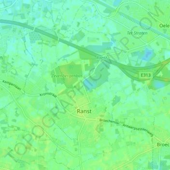
Name: Ranst topographic map, elevation, terrain.
Location: Ranst, Antwerpen, Vlaanderen, België (51.17504 4.53008 51.21741 4.59332)
Average elevation: 10 m
Minimum elevation: 4 m
Maximum elevation: 15 m
Make a donation
Gear up for your next adventure:
As an Amazon Associate, this site earns from qualifying purchases at no extra cost to you.
Other topographic maps
Click on a map to view its topography, its elevation and its terrain.