Geolocate

Sukowono topographic map

Click on the map to display elevation.

About this map

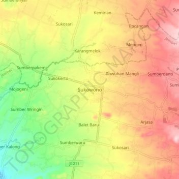
Name: Sukowono topographic map, elevation, terrain.

Location: Sukowono, Jember, East Java, Java, 68263, Indonesia (-8.09828 113.78922 -8.01828 113.86922)

Average elevation: 333 m

Minimum elevation: 200 m

Maximum elevation: 454 m

Gear up for your next adventure:

🔥Emergency Fire Starter - Reliable ignition source for all weather conditions
🥾Light Hiking Boots - Lightweight and comfortable boots for day hikes
💡LED Camping Lantern - Illuminate your campsite with long-lasting lanterns
🧢Hiking Hat - Sun-protective and breathable hats for long treks
🦶Hiking Shoe Insoles - Added support for high arches and long days on feet

As an Amazon Associate, this site earns from qualifying purchases at no extra cost to you.