Geolocate

Gebog topographic map

Click on the map to display elevation.

About this map

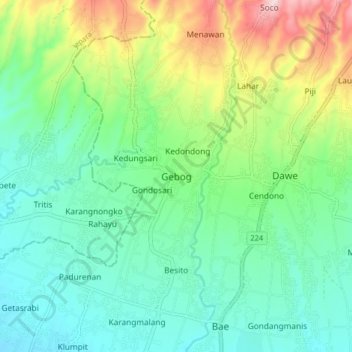
Name: Gebog topographic map, elevation, terrain.

Location: Gebog, Kudus, Central Java, Java, 59354, Indonesia (-6.77510 110.80407 -6.69510 110.88407)

Average elevation: 127 m

Minimum elevation: 27 m

Maximum elevation: 371 m

Gear up for your next adventure:

🧥Fleece Jacket - Warm and lightweight jacket for layering
🧊Portable Cooler - Keep food and drinks cold during outdoor adventures
🦶Hiking Shoe Insoles - Added support for high arches and long days on feet
Tent Footprint - Protect tent floor and increase durability
🥾Trail Hiking Socks - Comfortable socks to prevent blisters and fatigue

As an Amazon Associate, this site earns from qualifying purchases at no extra cost to you.