Geolocate

Wörl topographic map

Click on the map to display elevation.

About this map

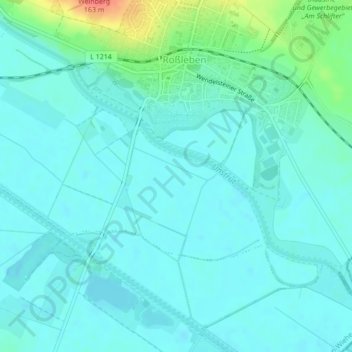
Name: Wörl topographic map, elevation, terrain.

Location: Wörl, Roßleben, Roßleben-Wiehe, Kyffhäuserkreis, Thuringia, 06571, Germany (51.27835 11.42175 51.29835 11.44175)

Average elevation: 121 m

Minimum elevation: 111 m

Maximum elevation: 165 m

Other topographic maps

Click on a map to view its topography, its elevation and its terrain.

Badra

Germany > Thuringia > Kyffhäuserkreis > Kyffhäuserland

Average elevation: 238 m

Voigtstedt

Germany > Thuringia > Kyffhäuserkreis > Artern

Average elevation: 134 m

99718

Germany > Thuringia > Kyffhäuserkreis > Wasserthaleben

Average elevation: 235 m

Langenroda

Germany > Thuringia > Kyffhäuserkreis

Average elevation: 236 m

Sondershausen

Germany > Thuringia > Kyffhäuserkreis

Average elevation: 273 m

Artern

Germany > Thuringia > Kyffhäuserkreis

Average elevation: 131 m

Greußen

Germany > Thuringia > Kyffhäuserkreis

Average elevation: 238 m

Voigtstedt

Germany > Thuringia > Kyffhäuserkreis > Artern

Average elevation: 134 m

Gear up for your next adventure:

Bushcraft Tarp - Versatile emergency shelter or gear protection
Lightweight Backpacking Tent - Compact tent for efficient hiking trips
Backpacking Tent - Lightweight tent for long-distance hiking trips
🧥Packable Rain Jacket - Breathable waterproof layer for unpredictable weather
💧Hydration Pack - Hands-free hydration system for long hikes

As an Amazon Associate, this site earns from qualifying purchases at no extra cost to you.