
Thank you for supporting this site ❤️
Make a donation
Make a donation
Gear up for your next adventure:
As an Amazon Associate, this site earns from qualifying purchases at no extra cost to you.
Mount Cook topographic map
Click on the map to display elevation.
Thank you for supporting this site ❤️
Make a donation
Make a donation
Gear up for your next adventure:
As an Amazon Associate, this site earns from qualifying purchases at no extra cost to you.
Mount Cook
庫克山是北美洲的山峰,位於美國阿拉斯加州和加拿大育空接壤的邊境,距離聖埃利亞斯山約35英哩,屬於聖埃利亞斯山脈的一部分,海拔高度4,196米。
Thank you for supporting this site ❤️
Make a donation
Make a donation
Gear up for your next adventure:
As an Amazon Associate, this site earns from qualifying purchases at no extra cost to you.
About this map
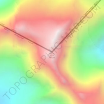
Name: Mount Cook topographic map, elevation, terrain.
Location: Mount Cook, Yakutat, 阿拉斯加州, 美利坚合众国/美利堅合眾國 (60.18192 -139.98114 60.18202 -139.98104)
Average elevation: 3,582 m
Minimum elevation: 2,891 m
Maximum elevation: 4,188 m
Thank you for supporting this site ❤️
Make a donation
Make a donation
Gear up for your next adventure:
As an Amazon Associate, this site earns from qualifying purchases at no extra cost to you.