Geolocate

Le Lorrain topographic map

Click on the map to display elevation.

About this map

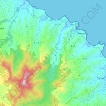
Name: Le Lorrain topographic map, elevation, terrain.

Location: Le Lorrain, La Trinité, Martinique, 97214, France (14.74639 -61.10821 14.85242 -61.03960)

Average elevation: 191 m

Minimum elevation: -2 m

Maximum elevation: 840 m

Other topographic maps

Click on a map to view its topography, its elevation and its terrain.

Canton Suisse

France > Martinique > Le Morne-Vert

Average elevation: 337 m

Baie de Fort-de-France

France > Martinique

Average elevation: 0 m

Domaine du Grand Macabou

France > Martinique > Le Marin

Average elevation: 19 m

Gear up for your next adventure:

🧦Hiking Socks - Moisture-wicking and comfortable socks for long hikes
🧰Emergency Multi-Tool - Compact multi-tool for outdoor survival
🥾Light Trekking Boots - Supportive boots for multi-day treks
🔭Outdoor Binoculars - Lightweight binoculars for birdwatching and hiking
🧦Merino Wool Socks - Moisture-wicking comfort for long-distance hiking

As an Amazon Associate, this site earns from qualifying purchases at no extra cost to you.