Geolocate

Steubenville topographic map

Click on the map to display elevation.

About this map

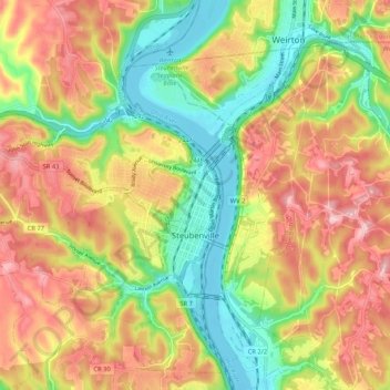
Name: Steubenville topographic map, elevation, terrain.

Location: Steubenville, Jefferson County, Ohio, 43952, United States (40.32823 -80.69751 40.40837 -80.60765)

Average elevation: 294 m

Minimum elevation: 198 m

Maximum elevation: 392 m

Gear up for your next adventure:

Tent Footprint - Protect tent floor and increase durability
Backpacking Tent - Lightweight tent for long-distance hiking trips
🧥Packable Rain Jacket - Breathable waterproof layer for unpredictable weather
🧢Outdoor Cap - Protective cap for sun and rain during hikes
🏃Hydration Running Vest - Carry water and maps close to your body for speed

As an Amazon Associate, this site earns from qualifying purchases at no extra cost to you.