
Make a donation
Gear up for your next adventure:
As an Amazon Associate, this site earns from qualifying purchases at no extra cost to you.
Johnstown topographic map
Click on the map to display elevation.
Make a donation
Gear up for your next adventure:
As an Amazon Associate, this site earns from qualifying purchases at no extra cost to you.
About this map
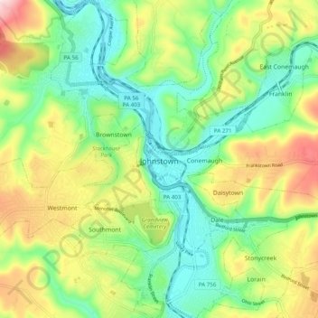
Name: Johnstown topographic map, elevation, terrain.
Location: Johnstown, Cambria County, Pennsylvania, United States (40.28982 -78.95523 40.36415 -78.88233)
Average elevation: 469 m
Minimum elevation: 341 m
Maximum elevation: 691 m
Make a donation
Gear up for your next adventure:
As an Amazon Associate, this site earns from qualifying purchases at no extra cost to you.
Other topographic maps
Click on a map to view its topography, its elevation and its terrain.
Saint Benedict
United States > Pennsylvania > Cambria County > West Carroll Township
Average elevation: 582 m
Make a donation
Gear up for your next adventure:
As an Amazon Associate, this site earns from qualifying purchases at no extra cost to you.
Saint Boniface
United States > Pennsylvania > Cambria County > Elder Township
Average elevation: 593 m
Make a donation
Gear up for your next adventure:
As an Amazon Associate, this site earns from qualifying purchases at no extra cost to you.
South Fork of the Little Conemaugh River
United States > Pennsylvania > Cambria County > Croyle Township > Rockville
Average elevation: 535 m
Beaver Valley
United States > Pennsylvania > Cambria County > Clearfield Township
Average elevation: 492 m
Make a donation
Gear up for your next adventure:
As an Amazon Associate, this site earns from qualifying purchases at no extra cost to you.
Make a donation
Gear up for your next adventure:
As an Amazon Associate, this site earns from qualifying purchases at no extra cost to you.