Geolocate

Rubín topographic map

Click on the map to display elevation.

About this map

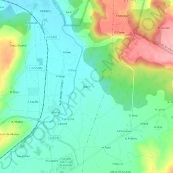
Name: Rubín topographic map, elevation, terrain.

Location: Rubín, Sarria, Lugo, Galicia, 27614, España (42.79584 -7.39547 42.83584 -7.35547)

Average elevation: 430 m

Minimum elevation: 387 m

Maximum elevation: 521 m

Other topographic maps

Click on a map to view its topography, its elevation and its terrain.

Chorente

España > Galicia > Sarria > Sarria

Average elevation: 626 m

Barbadelo

España > Galicia > Sarria > Sarria

Average elevation: 576 m

Ortoá

España > Galicia > Sarria > Sarria

Average elevation: 614 m

Louseiro

España > Galicia > Sarria > Sarria

Average elevation: 507 m

Vilamaior

España > Galicia > Sarria > Sarria

Average elevation: 623 m

Santo André de Paradela

España > Galicia > Sarria > Sarria

Average elevation: 578 m

Fontao

España > Galicia > Sarria > Sarria

Average elevation: 460 m

Gear up for your next adventure:

🎒Hiking Backpack - Lightweight and ergonomic backpacks for day hikes or multi-day treks
🔭Compact Binoculars - Lightweight optics for scouting trails and wildlife
🧴Bear Spray Holster - Quick-access carry for essential Canadian wilderness safety
Camping Groundsheet - Protect your tent from moisture and dirt
Tent Footprint - Protect tent floor and increase durability

As an Amazon Associate, this site earns from qualifying purchases at no extra cost to you.