Geolocate

Cangas topographic map

Click on the map to display elevation.

About this map

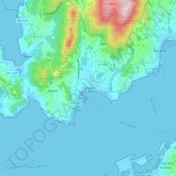
Name: Cangas topographic map, elevation, terrain.

Location: Cangas, O Morrazo, Pontevedra, Galicia, 36940, Spain (42.22472 -8.81965 42.30472 -8.73965)

Average elevation: 54 m

Minimum elevation: -1 m

Maximum elevation: 436 m

Gear up for your next adventure:

🔋Emergency Crank Radio - Weather alerts and power without needing batteries
🦶Anti-Blister Balm - Prevents friction and hotspots during long ascents
🧴Bear Spray Holster - Quick-access carry for essential Canadian wilderness safety
🥾Trekking Poles - Adjustable trekking poles to reduce knee stress and improve stability
🦟Insect Repellent - Keep mosquitoes and black flies away in wooded areas

As an Amazon Associate, this site earns from qualifying purchases at no extra cost to you.