
Make a donation
Gear up for your next adventure:
As an Amazon Associate, this site earns from qualifying purchases at no extra cost to you.
Zitácuaro topographic map
Click on the map to display elevation.
Make a donation
Gear up for your next adventure:
As an Amazon Associate, this site earns from qualifying purchases at no extra cost to you.
Zitácuaro
Zitácuaro stands at 19°26′N 100°22′W / 19.433°N 100.367°W / 19.433; -100.367, in the northeast corner of Michoacán, some 150 km east of state capital Morelia, at an elevation of 1,942 metres above sea level. The municipality covers a total of 498 km2 and is drained by the Río Zitácuaro, the Río San Andrés, and the Río San Juan Viejo. The surrounding terrain are avocado orchards and the pine-covered mountains of the Sierra Madre Occidental; to the north of Zitácuaro are the famed Mexican wintering grounds of the monarch butterfly.
Make a donation
Gear up for your next adventure:
As an Amazon Associate, this site earns from qualifying purchases at no extra cost to you.
About this map
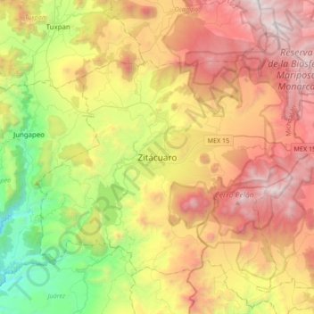
Name: Zitácuaro topographic map, elevation, terrain.
Location: Zitácuaro, Michoacán, 61506, Mexico (19.27440 -100.51531 19.59440 -100.19531)
Average elevation: 2,157 m
Minimum elevation: 905 m
Maximum elevation: 3,624 m
Make a donation
Gear up for your next adventure:
As an Amazon Associate, this site earns from qualifying purchases at no extra cost to you.