
Make a donation
Gear up for your next adventure:
As an Amazon Associate, this site earns from qualifying purchases at no extra cost to you.
Causse-et-Diège topographic map
Click on the map to display elevation.
Make a donation
Gear up for your next adventure:
As an Amazon Associate, this site earns from qualifying purchases at no extra cost to you.
Causse-et-Diège
Le Lot prend sa source à 1272 m d’altitude sur la montagne du Goulet (nord du Mont Lozère), dans la commune de Cubières (48), et se jette dans la Garonne à Monheurt (47), après avoir parcouru 484 km et traversé 129 communes.
Make a donation
Gear up for your next adventure:
As an Amazon Associate, this site earns from qualifying purchases at no extra cost to you.
About this map
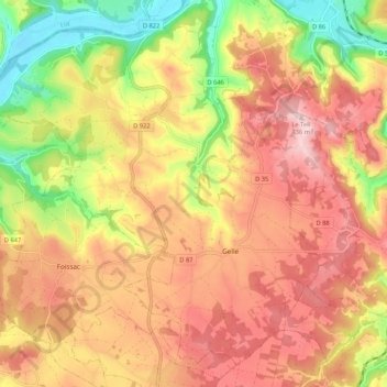
Name: Causse-et-Diège topographic map, elevation, terrain.
Average elevation: 312 m
Minimum elevation: 155 m
Maximum elevation: 432 m
Make a donation
Gear up for your next adventure:
As an Amazon Associate, this site earns from qualifying purchases at no extra cost to you.