Geolocate

Abungan topographic map

Click on the map to display elevation.

About this map

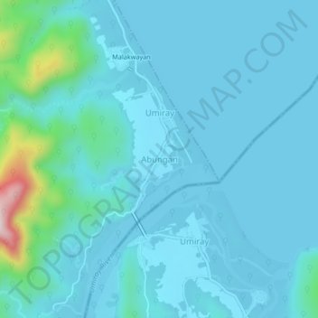
Name: Abungan topographic map, elevation, terrain.

Location: Abungan, Dingalan, Aurora, Central Luzon, Philippines (15.20029 121.39147 15.24029 121.43147)

Average elevation: 45 m

Minimum elevation: -2 m

Maximum elevation: 430 m

Other topographic maps

Click on a map to view its topography, its elevation and its terrain.

Umiray River

Philippines > Aurora > Dingalan > Abungan

Average elevation: 93 m

Dingalan River

Philippines > Aurora > Dingalan

Average elevation: 188 m

Gear up for your next adventure:

Backpacking Tent - Lightweight tent for long-distance hiking trips
🥾Trail Running Shoes - Lightweight and durable shoes for trail running
🧳Compression Sacks - Maximize space in your backpack by shrinking gear
🧢Hiking Hat - Sun-protective and breathable hats for long treks
🥾Trail Running Boots - Durable shoes designed for trail running

As an Amazon Associate, this site earns from qualifying purchases at no extra cost to you.