
Zapopan topographic map
Click on the map to display elevation.
Zapopan
Most of the municipality is flat with another quarter having rolling hills. Altitude varies from 1,500 to 2,000 metres (4,900 to 6,600 ft) above sea level. The main elevations are in the Sierra de la Primavera and include Nejahuete, Tajo, and El Chapulin. Superficial water flows mostly in arroyos east to the Grande or Santiago River. In the center of the municipality there are three dams called the Copalita, the Santa Lucia and the San Jose. Winters here are mild and usually are noticeable only in the higher elevations. Average year-round temperature is 22 °C with highs of 36 °C and lows of 11 °C. Rain principally falls from June to October. Vegetation in the municipality varies from pines and holm oaks in the Sierra de la Primavera and species such as jonote (Heliocarpus appendiculatus), strawberry trees and nopals in the lower elevations. While wildlife has nearly disappeared from this area, the Bosque el Nixticuil on the northern edge of the urban sprawl has been designated as a protected natural area and still is home to many mammals, reptiles, amphibians, birds, and insects.
About this map
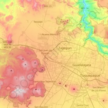
Name: Zapopan topographic map, elevation, terrain.
Location: Zapopan, Región Centro, Jalisco, 45101, Mexico (20.56112 -103.55137 20.88112 -103.23137)
Average elevation: 1,598 m
Minimum elevation: 886 m
Maximum elevation: 2,257 m