
Murang'a topographic map
Click on the map to display elevation.
Murang'a
The town is low, a bit hilly, small but picturesque with an altitude of 4120 ft (1255 metres) above sea level. As a result of the varying altitudes, Murang'a can get quite cold from May to mid-August, and can experience hail. To the west of the town can be seen the rolling Kikuyu farmlands that extend as far as the eyes can see.
About this map
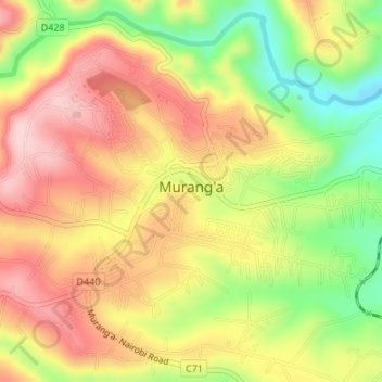
Name: Murang'a topographic map, elevation, terrain.
Location: Murang'a, Kiharu, Murang'a County, Central Kenya, 10200, Kenya (-0.73750 37.13963 -0.71061 37.17323)
Average elevation: 1,286 m
Minimum elevation: 1,161 m
Maximum elevation: 1,387 m