Geolocate

Lashio Township topographic map

Click on the map to display elevation.

About this map
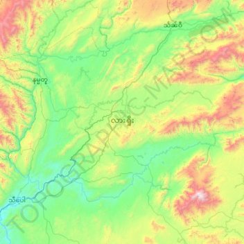
Name: Lashio Township topographic map, elevation, terrain.

Location: Lashio Township, Lashio District, North Shan State, Shan State, 06301, Myanmar (22.61366 97.51502 23.24171 98.55735)

Average elevation: 907 m

Minimum elevation: 396 m

Maximum elevation: 2,653 m

Other topographic maps

Click on a map to view its topography, its elevation and its terrain.
Kalaw

Myanmar > Shan State > Kalaw Township

The hill station is located at an elevation of 1310 metres, 50 km from the Inle lake. Kalaw is famous for hiking and trekking. Many trekking trails ranging from nearby places to Inle Lake and Pindaya. The town still feels like a high-altitude holiday resort – the air is cool, the atmosphere is calm and the…

Average elevation: 1,348 m

Yan Aung May

Myanmar > Shan State > Lashio

Average elevation: 822 m

Doi Lang

Myanmar > Shan State > Mong Hsat District

Average elevation: 1,853 m

Gear up for your next adventure:

🚲MTB Frame Bag - Carry tools and maps directly on your bicycle frame
💡Solar Camping Lamp - Eco-friendly lighting for campsites
🧭GPS Tracker - Track your location in remote areas safely
🛌Insulated Sleeping Pad - Critical thermal barrier between you and the cold ground
🥾Lightweight Hiking Boots - Boots for comfort and mobility on long hikes

As an Amazon Associate, this site earns from qualifying purchases at no extra cost to you.