
Make a donation
Gear up for your next adventure:
As an Amazon Associate, this site earns from qualifying purchases at no extra cost to you.
Lashio Township topographic map
Click on the map to display elevation.
Make a donation
Gear up for your next adventure:
As an Amazon Associate, this site earns from qualifying purchases at no extra cost to you.
About this map
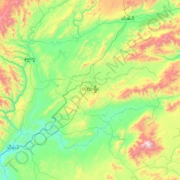
Name: Lashio Township topographic map, elevation, terrain.
Average elevation: 907 m
Minimum elevation: 396 m
Maximum elevation: 2,653 m
Make a donation
Gear up for your next adventure:
As an Amazon Associate, this site earns from qualifying purchases at no extra cost to you.
Other topographic maps
Click on a map to view its topography, its elevation and its terrain.
Taunggyi
Taunggyi (Burmese: တောင်ကြီးမြို့; MLCTS: taung kri: mrui. [tàʊɰ̃dʑí mjo̰]; Shan: ဝဵင်းတူၼ်ႈတီး Shan pronunciation: [weŋ˥ ton˧˧˨ ti˥]) is the capital and largest city of Shan State, Myanmar (Burma) and lies on the Thazi-Kyaingtong road at an…
Average elevation: 1,149 m
Kalaw
Myanmar > Shan State > Kalaw Township
The hill station is located at an elevation of 1310 metres, 50 km from the Inle lake. Kalaw is famous for hiking and trekking. Many trekking trails ranging from nearby places to Inle Lake and Pindaya. The town still feels like a high-altitude holiday resort – the air is cool, the atmosphere is calm and the…
Average elevation: 1,348 m
Make a donation
Gear up for your next adventure:
As an Amazon Associate, this site earns from qualifying purchases at no extra cost to you.