Geolocate

Kasba topographic map

Click on the map to display elevation.

About this map

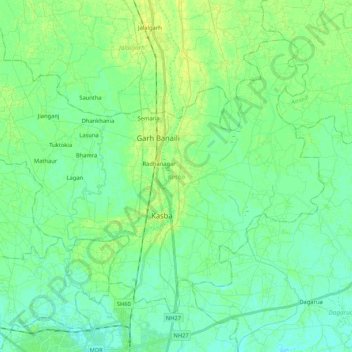
Name: Kasba topographic map, elevation, terrain.

Location: Kasba, Purnia district, Bihar, India (25.80507 87.42564 25.95141 87.63519)

Average elevation: 41 m

Minimum elevation: 35 m

Maximum elevation: 48 m

Gear up for your next adventure:

🧥Thermal Layer - Insulating layer for cold outdoor conditions
🧴Sunscreen SPF - Broad-spectrum sunscreen for outdoor activities
🥾Hiking Shoes - Durable and comfortable shoes for trail hiking
🔦UV Flashlight - Detect minerals or specific insects in the dark
👟Sport Hiking Sandals - Breathable footwear for water crossings and camp rest

As an Amazon Associate, this site earns from qualifying purchases at no extra cost to you.