Geolocate

Hintersee topographic map

Click on the map to display elevation.

About this map

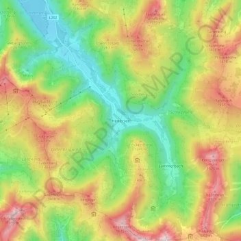
Name: Hintersee topographic map, elevation, terrain.

Location: Hintersee, Bezirk Salzburg-Umgebung, Salzburg, 5324, Austria (47.67465 13.23237 47.75206 13.34025)

Average elevation: 1,117 m

Minimum elevation: 681 m

Maximum elevation: 1,695 m

Other topographic maps

Click on a map to view its topography, its elevation and its terrain.

Berg

Austria > Salzburg > Bezirk Salzburg-Umgebung

Average elevation: 489 m

Irrsdorf

Austria > Salzburg > Bezirk Salzburg-Umgebung

Average elevation: 588 m

Schober

Austria > Salzburg > Bezirk Salzburg-Umgebung > Thalgau

Average elevation: 834 m

Wals

Austria > Salzburg > Bezirk Salzburg-Umgebung

Average elevation: 440 m

Winding

Austria > Salzburg > Bezirk Salzburg-Umgebung > Bergheim

Average elevation: 517 m

Gastein

Austria > Salzburg > Bezirk Salzburg-Umgebung > Schlößl

Average elevation: 493 m

Oberburgau

Austria > Salzburg > Bezirk Salzburg-Umgebung

Average elevation: 778 m

Tiefenbach

Austria > Salzburg > Bezirk Salzburg-Umgebung

Average elevation: 541 m

Gear up for your next adventure:

🥾Hiking Shoes - Durable and comfortable shoes for trail hiking
🪑Insulated Seat Pad - Protect your seat from cold rocks and wet logs
🥾Approach Shoes - Shoes designed for climbing approaches and rugged trails
🥾Hiking Boots - Sturdy boots providing ankle support and traction on rugged trails
🦯Trekking Poles - Reduced impact on joints for steep topographic climbs

As an Amazon Associate, this site earns from qualifying purchases at no extra cost to you.