Geolocate

Zaandam topographic map

Click on the map to display elevation.

About this map
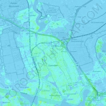
Name: Zaandam topographic map, elevation, terrain.

Location: Zaandam, Zaanstad, North Holland, Netherlands (52.41666 4.78344 52.48397 4.86281)

Average elevation: 0 m

Minimum elevation: -7 m

Maximum elevation: 10 m

Other topographic maps

Click on a map to view its topography, its elevation and its terrain.
Amsterdam

Netherlands > North Holland > Amsterdam

Average elevation: -1 m

Oosterwijzend

Netherlands > North Holland > Hoogkarspel

Average elevation: -2 m

Gear up for your next adventure:

🧭GPS Tracker - Track your location in remote areas safely
🧤Thermal Hiking Gloves - Grip-enhanced gloves for cold-weather altitude trekking
🪜Heavy Duty Carabiners - Multi-use clips for securing gear to your backpack
🧦Merino Wool Socks - Moisture-wicking comfort for long-distance hiking
🥾Trekking Poles - Adjustable trekking poles to reduce knee stress and improve stability

As an Amazon Associate, this site earns from qualifying purchases at no extra cost to you.