Geolocate

Kuriam topographic map

Click on the map to display elevation.

About this map

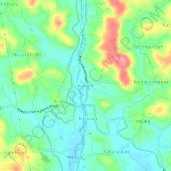
Name: Kuriam topographic map, elevation, terrain.

Location: Kuriam, Meenachil, Kottayam, Kerala, 686633, India (9.71542 76.54134 9.75542 76.58134)

Average elevation: 38 m

Minimum elevation: 8 m

Maximum elevation: 98 m

Gear up for your next adventure:

🧢Beanie Hat - Keep your head warm in cold weather
🧢Sun Hat - Wide-brim hat for sun protection
💡Solar Camping Lamp - Eco-friendly lighting for campsites
🥾Lightweight Hiking Boots - Boots for comfort and mobility on long hikes
🛏️Camping Sleeping Mat - Comfortable mats for sleeping outdoors

As an Amazon Associate, this site earns from qualifying purchases at no extra cost to you.