
Make a donation
Gear up for your next adventure:
As an Amazon Associate, this site earns from qualifying purchases at no extra cost to you.
High Point topographic map
Click on the map to display elevation.
Make a donation
Gear up for your next adventure:
As an Amazon Associate, this site earns from qualifying purchases at no extra cost to you.
About this map
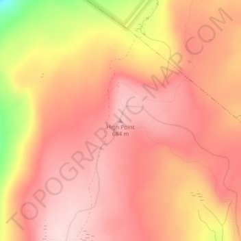
Name: High Point topographic map, elevation, terrain.
Average elevation: 623 m
Minimum elevation: 441 m
Maximum elevation: 693 m
Make a donation
Gear up for your next adventure:
As an Amazon Associate, this site earns from qualifying purchases at no extra cost to you.
Other topographic maps
Click on a map to view its topography, its elevation and its terrain.
Minnewaska State Park Preserve
United States > New York > Ulster County > Town of Wawarsing
Average elevation: 279 m
Village of Ellenville
United States > New York > Ulster County > Town of Wawarsing
Average elevation: 325 m
Village of Ellenville
United States > New York > Ulster County > Town of Wawarsing
Average elevation: 325 m
Make a donation
Gear up for your next adventure:
As an Amazon Associate, this site earns from qualifying purchases at no extra cost to you.
Village of Ellenville
United States > New York > Ulster County > Town of Wawarsing
Average elevation: 325 m
Village of Ellenville
United States > New York > Ulster County > Town of Wawarsing
Average elevation: 325 m
Make a donation
Gear up for your next adventure:
As an Amazon Associate, this site earns from qualifying purchases at no extra cost to you.