Geolocate

Baruth - Bart topographic map

Click on the map to display elevation.

About this map

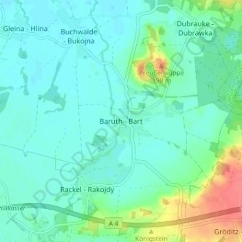
Name: Baruth - Bart topographic map, elevation, terrain.

Location: Baruth - Bart, Malschwitz - Malešecy, Bautzen - Budyšin, Saxony, Germany (51.20549 14.57028 51.24549 14.61028)

Average elevation: 157 m

Minimum elevation: 144 m

Maximum elevation: 198 m

Other topographic maps

Click on a map to view its topography, its elevation and its terrain.

Bautzen

Germany > Saxony > Bautzen - Budyšin

Average elevation: 210 m

Ottendorf-Okrilla

Germany > Saxony > Bautzen - Budyšin

Average elevation: 193 m

Wachau

Germany > Saxony > Bautzen - Budyšin

Average elevation: 234 m

01906

Germany > Saxony > Bautzen - Budyšin > Uhyst am Taucher

Average elevation: 240 m

Arnsdorf

Germany > Saxony > Bautzen - Budyšin

Average elevation: 272 m

Gear up for your next adventure:

💧Reusable Water Bottle - Durable water bottles for hydration on trails
🧥Waterproof Pants - Keep dry during rainy hiking conditions
🥾Approach Shoes - Shoes designed for climbing approaches and rugged trails
🧥Thermal Layer - Insulating layer for cold outdoor conditions
🧦Hiking Socks - Moisture-wicking and comfortable socks for long hikes

As an Amazon Associate, this site earns from qualifying purchases at no extra cost to you.