Geolocate

Anyer topographic map

Click on the map to display elevation.

About this map

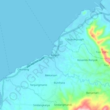
Name: Anyer topographic map, elevation, terrain.

Location: Anyer, Kab Serang, Banten, Java, 42166, Indonesia (-6.09327 105.88274 -6.01327 105.96274)

Average elevation: 25 m

Minimum elevation: -2 m

Maximum elevation: 266 m

Gear up for your next adventure:

🧢Outdoor Cap - Protective cap for sun and rain during hikes
🔋Lithium AA Batteries - Long-lasting power that performs in extreme cold
🧊Portable Cooler - Keep food and drinks cold during outdoor adventures
🕶️Polarized Sunglasses - Protect your eyes with durable polarized lenses
💧Hydration Pack - Hands-free hydration system for long hikes

As an Amazon Associate, this site earns from qualifying purchases at no extra cost to you.