Geolocate

Lagunillas topographic map

Click on the map to display elevation.

About this map

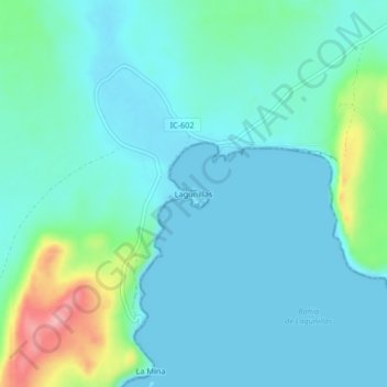
Name: Lagunillas topographic map, elevation, terrain.

Location: Lagunillas, Paracas, Pisco, Ica, Perú (-13.91716 -76.33203 -13.87716 -76.29203)

Average elevation: 26 m

Minimum elevation: 0 m

Maximum elevation: 143 m

Other topographic maps

Click on a map to view its topography, its elevation and its terrain.

Playa La Mina

Perú > Ica > Paracas > La Mina

Average elevation: 32 m

Playa Carhuaz

Perú > Ica > Paracas

Average elevation: 43 m

Playa El Raspón

Perú > Ica > Paracas

Average elevation: 32 m

Bahía de Paracas

Perú > Ica > Paracas

Average elevation: 12 m

Playa La Mina

Perú > Ica > Paracas > La Mina

Average elevation: 32 m

Gear up for your next adventure:

🔦LED Headtorch - Bright and durable light for night activities
👖Convertible Hiking Pants - Zip-off legs to adapt to changing weather conditions
🔭Outdoor Binoculars - Lightweight binoculars for birdwatching and hiking
🧢Hiking Hat - Sun-protective and breathable hats for long treks
🧊Insulated Water Bottle - Keeps drinks cold in summer and prevents freezing in winter

As an Amazon Associate, this site earns from qualifying purchases at no extra cost to you.