
Make a donation
Gear up for your next adventure:
As an Amazon Associate, this site earns from qualifying purchases at no extra cost to you.
Haillot topographic map
Click on the map to display elevation.
Make a donation
Gear up for your next adventure:
As an Amazon Associate, this site earns from qualifying purchases at no extra cost to you.
About this map
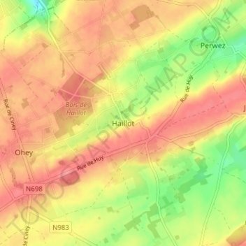
Name: Haillot topographic map, elevation, terrain.
Average elevation: 255 m
Minimum elevation: 208 m
Maximum elevation: 284 m
Make a donation
Gear up for your next adventure:
As an Amazon Associate, this site earns from qualifying purchases at no extra cost to you.
Other topographic maps
Click on a map to view its topography, its elevation and its terrain.
Make a donation
Gear up for your next adventure:
As an Amazon Associate, this site earns from qualifying purchases at no extra cost to you.
Make a donation
Gear up for your next adventure:
As an Amazon Associate, this site earns from qualifying purchases at no extra cost to you.
Tamines
Belgique > Province de Namur > Namur > Sambreville
Positionnée sur un faible versant d’adret, à une altitude moyenne de 110 mètres (103 mètres au seuil de la gare), Tamines comporte néanmoins des différences de relief sensibles, entre les rives de la Sambre (93 mètres) et les hauts de versant du Tienne d’Amion au sud et du Bois du Chesselet au nord…
Average elevation: 109 m