Geolocate

Ubon Ratchathani topographic map

Click on the map to display elevation.

Ubon Ratchathani

The elevation is 410 ft (125 m). It is 615 km (382 mi) from Bangkok.

Wikipedia (CC-BY-SA 3.0)

About this map

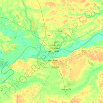
Name: Ubon Ratchathani topographic map, elevation, terrain.

Location: Ubon Ratchathani, Pathum, Ubon Ratchathani Province, 34000, Thailand (15.06742 104.69895 15.38742 105.01895)

Average elevation: 125 m

Minimum elevation: 108 m

Maximum elevation: 147 m

Gear up for your next adventure:

🎒Fully Waterproof Backpack - Total protection for photography gear and electronics
🦶Hiking Shoe Insoles - Added support for high arches and long days on feet
Camping Tent - Weather-resistant tents suitable for 2 to 6 people
Tent Footprint - Protect tent floor and increase durability
🥾Trail Hiking Shoes - Durable shoes designed for rugged trails

As an Amazon Associate, this site earns from qualifying purchases at no extra cost to you.