Geolocate

Amicalola topographic map

Click on the map to display elevation.

About this map

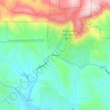
Name: Amicalola topographic map, elevation, terrain.

Location: Amicalola, Dawson County, Georgia, United States (34.53481 -84.27242 34.57481 -84.23242)

Average elevation: 592 m

Minimum elevation: 456 m

Maximum elevation: 855 m

Other topographic maps

Click on a map to view its topography, its elevation and its terrain.

Dawsonville

United States > Georgia > Dawson County

Average elevation: 411 m

Dawsonville

United States > Georgia > Dawson County

Average elevation: 411 m

Dawsonville

United States > Georgia > Dawson County

Average elevation: 411 m

Dawsonville

United States > Georgia > Dawson County

Average elevation: 412 m

Gear up for your next adventure:

🧤Thermal Hiking Gloves - Grip-enhanced gloves for cold-weather altitude trekking
🧰Survival Kit - Essential gear for emergencies in the wilderness
🥽Outdoor Goggles - Protective eyewear for outdoor activities
🥾Mountain Hiking Shoes - Shoes with superior grip for mountainous terrain
🕶️Polarized Sunglasses - Protect your eyes with durable polarized lenses

As an Amazon Associate, this site earns from qualifying purchases at no extra cost to you.