Geolocate

Hochstadt topographic map

Click on the map to display elevation.

About this map

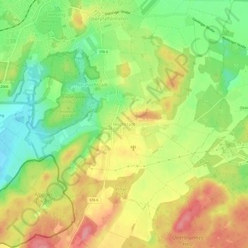
Name: Hochstadt topographic map, elevation, terrain.

Location: Hochstadt, Weßling, Wörthsee, Landkreis Starnberg, Bavaria, 82234, Germany (48.03621 11.24874 48.07621 11.28874)

Average elevation: 609 m

Minimum elevation: 557 m

Maximum elevation: 663 m

Other topographic maps

Click on a map to view its topography, its elevation and its terrain.

Pöcking

Germany > Bavaria > Landkreis Starnberg

Average elevation: 638 m

Berg

Germany > Bavaria > Landkreis Starnberg

Average elevation: 630 m

Tutzing

Germany > Bavaria > Landkreis Starnberg

Average elevation: 632 m

Gauting

Germany > Bavaria > Landkreis Starnberg

Average elevation: 593 m

Gear up for your next adventure:

🥾Hiking Shorts - Breathable shorts suitable for summer hikes
🧢Beanie Hat - Keep your head warm in cold weather
🛶Waterproof Dry Bags - Keep electronics and clothes dry during river crossings
🧢Outdoor Visor - Breathable visor for sunny hikes
🥾Approach Boots - Comfortable boots for hiking and climbing approaches

As an Amazon Associate, this site earns from qualifying purchases at no extra cost to you.