Geolocate

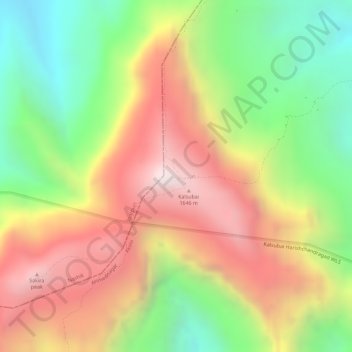
Kalasubai peak topographic map

Click on the map to display elevation.

Kalasubai peak

Kalsubai (Marathi: कळसूबाई शिखर) is a mountain in the Western Ghats, located in the Indian state of Maharashtra. Its summit, situated at an elevation of 1,646 metres (5,400 ft), is the highest point in Maharashtra.

Wikipedia (CC-BY-SA 3.0)

About this map

Name: Kalasubai peak topographic map, elevation, terrain.

Location: Kalasubai peak, Akola, Ahmednagar District, Maharashtra, India (19.60026 73.71090 19.60036 73.71100)

Average elevation: 1,210 m

Minimum elevation: 784 m

Maximum elevation: 1,617 m

Other topographic maps

Click on a map to view its topography, its elevation and its terrain.

Kothari

India > Maharashtra > Akola

Average elevation: 299 m

Umerkhed

India > Maharashtra > Akola

Average elevation: 284 m

Nizampur

India > Maharashtra > Akola

Average elevation: 280 m

Hingna Barling

India > Maharashtra > Akola

Average elevation: 286 m

Nawakheda

India > Maharashtra > Akola

Average elevation: 270 m

Pahadpur

India > Maharashtra > Akola

Average elevation: 299 m

Dongargaon

India > Maharashtra > Akola > Dongargaon

Average elevation: 294 m

Babhulgaon

India > Maharashtra > Akola > Babhulgaon

Average elevation: 294 m

Borgaon Manju

India > Maharashtra > Akola

Average elevation: 295 m

Gear up for your next adventure:

🔥Emergency Fire Starter - Reliable ignition source for all weather conditions
🔭Outdoor Binoculars - Lightweight binoculars for birdwatching and hiking
🩹Compact First Aid Kit - Pre-packed essentials for common trail injuries
⛺Camping Tent - Weather-resistant tents suitable for 2 to 6 people
🧢Hiking Hat - Sun-protective and breathable hats for long treks

As an Amazon Associate, this site earns from qualifying purchases at no extra cost to you.