Geolocate

Maydolong topographic map

Click on the map to display elevation.

About this map

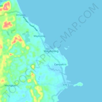
Name: Maydolong topographic map, elevation, terrain.

Location: Maydolong, Eastern Samar, Eastern Visayas, Philippines (11.46102 125.46168 11.54102 125.54168)

Average elevation: 14 m

Minimum elevation: -1 m

Maximum elevation: 135 m

Other topographic maps

Click on a map to view its topography, its elevation and its terrain.

Borongan City

Philippines > Eastern Samar

Average elevation: 11 m

Tikling

Philippines > Eastern Samar

Average elevation: 0 m

Hilabaan

Philippines > Eastern Samar

Average elevation: 1 m

Homonhon Island

Philippines > Eastern Samar > Culasi

Average elevation: 27 m

Calicoan Island

Philippines > Eastern Samar > Ngolos

Average elevation: 4 m

Manicani Island

Philippines > Eastern Samar > Banaag

Average elevation: 18 m

Homonhon Island

Philippines > Eastern Samar > Culasi

Average elevation: 27 m

Jipapad

Philippines > Eastern Samar

Average elevation: 110 m

Suluan Island

Philippines > Eastern Samar > Suluan

Average elevation: 12 m

Homonhon Island

Philippines > Eastern Samar > Habag

Average elevation: 27 m

Oras

Philippines > Eastern Samar > Jipapad

Average elevation: 37 m

Gear up for your next adventure:

👟Leg Gaiters - Keep debris, mud, and snow out of your boots
🧴Insect Repellent - Protect yourself from bugs during outdoor adventures
🧢Outdoor Visor - Breathable visor for sunny hikes
🧥Softshell Hiking Jacket - The perfect balance of wind protection and breathability
🌡️Emergency Mylar Blankets - Compact thermal protection for unexpected nights outdoors

As an Amazon Associate, this site earns from qualifying purchases at no extra cost to you.