
Make a donation
Gear up for your next adventure:
As an Amazon Associate, this site earns from qualifying purchases at no extra cost to you.
Antsirabe topographic map
Click on the map to display elevation.
Make a donation
Gear up for your next adventure:
As an Amazon Associate, this site earns from qualifying purchases at no extra cost to you.
Antsirabe
Antsirabe is situated at an altitude of about 1,500 m (4,900 ft), making its subtropical highland climate (Köppen: Cwb), similar to Brazilian high cities of the southeast. During the winter the temperature can fall below 0 °C (32 °F) at night, and Antsirabe has recorded the lowest temperature in Madagascar at −1.0 °C (30.2 °F).
Make a donation
Gear up for your next adventure:
As an Amazon Associate, this site earns from qualifying purchases at no extra cost to you.
About this map
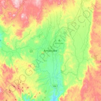
Name: Antsirabe topographic map, elevation, terrain.
Average elevation: 1,671 m
Minimum elevation: 1,352 m
Maximum elevation: 2,159 m
Make a donation
Gear up for your next adventure:
As an Amazon Associate, this site earns from qualifying purchases at no extra cost to you.