
Make a donation
Gear up for your next adventure:
As an Amazon Associate, this site earns from qualifying purchases at no extra cost to you.
Okerstausee topographic map
Click on the map to display elevation.
Make a donation
Gear up for your next adventure:
As an Amazon Associate, this site earns from qualifying purchases at no extra cost to you.
About this map
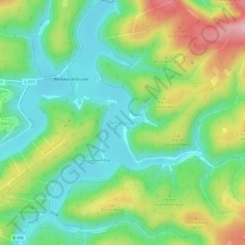
Name: Okerstausee topographic map, elevation, terrain.
Average elevation: 480 m
Minimum elevation: 407 m
Maximum elevation: 612 m
Make a donation
Gear up for your next adventure:
As an Amazon Associate, this site earns from qualifying purchases at no extra cost to you.
Other topographic maps
Click on a map to view its topography, its elevation and its terrain.
Bruchberg
Deutschland > Niedersachsen > Landkreis Goslar > Harz (LK Goslar)
Der Bruchberg liegt südöstlich des Kernorts der Bergstadt Altenau, südwestlich vom Altenauer Ortsteil Torfhaus und etwas nördlich von Sankt Andreasberg, einem Stadtteil von Braunlage. Die Hänge dieser fast allseits sanft ansteigenden weitläufigen Aufwölbung sind überwiegend von den vielen dort…
Average elevation: 832 m
Polsterberg
Deutschland > Niedersachsen > Landkreis Goslar > Harz (LK Goslar)
Average elevation: 583 m
NSG Bachtäler im Oberharz um Braunlage
Deutschland > Niedersachsen > Landkreis Goslar > Harz (LK Goslar) > Hohegeiß
Average elevation: 571 m
Make a donation
Gear up for your next adventure:
As an Amazon Associate, this site earns from qualifying purchases at no extra cost to you.
Steimkerberg
Deutschland > Niedersachsen > Landkreis Goslar > Harz (LK Goslar)
Average elevation: 477 m
Make a donation
Gear up for your next adventure:
As an Amazon Associate, this site earns from qualifying purchases at no extra cost to you.
Achtermannshöhe
Deutschland > Niedersachsen > Landkreis Goslar > Harz (LK Goslar)
Gipfel der Achtermannshöhe
Average elevation: 795 m
Marienteichbaude
Deutschland > Niedersachsen > Landkreis Goslar > Harz (LK Goslar)
Average elevation: 599 m